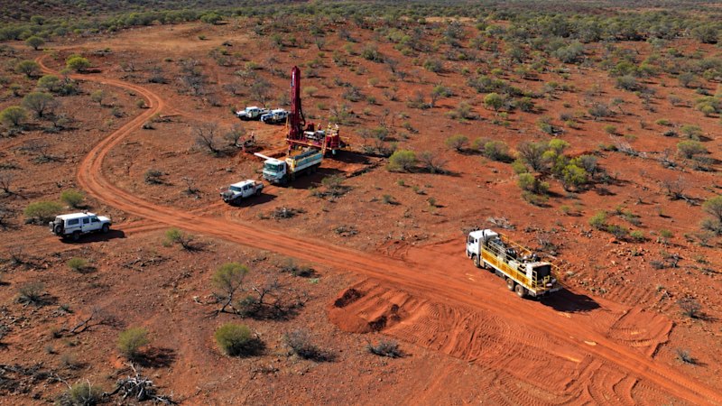
In the vast, sun-baked expanse of Western Australia’s Murchison region, gold has always been a game of patience and geology. For decades, explorers have walked these red-earth tracks, chipping away at rock faces to find traces of the precious metal. But the tools of discovery are shifting beneath their feet. The heavy boots of field geologists are now sharing space with the silent, sweeping gaze of satellites, transforming how companies like PLC Resources identify where to dig next.

At the heart of this shift is the Abbotts gold project, a sprawling 205-square-kilometer tract that holds a storied past but remains largely untapped in its modern potential. Historically, the area has yielded 41,000 ounces of gold, a respectable figure that suggests the ground is fertile. However, the average grade of that historical production sat at just 31 grams per tonne—a modest return by today’s high-grade standards. For years, the narrative was one of diminishing returns, a story of a district that had given up its easy secrets. That narrative is now being rewritten, not by deeper digging, but by looking from higher up.
PLC Resources has moved beyond traditional ground-based surveys alone, enlisting the services of Geo Spectra, a remote-sensing specialist, to undertake a comprehensive satellite-based assessment of the ground. This is not merely about taking pictures; it is about reading the chemical fingerprints left on the landscape. By utilizing modern exploration methods, including high-resolution satellite imagery, the company has uncovered promising gold targets that were previously obscured or overlooked. The work has revealed specific alteration patterns and geological structures indicative of orogenic gold deposits—those formed by ancient tectonic forces deep within the earth’s crust.
The Murchison region itself is known for its robust gold endowment, hosting several major mines and numerous smaller prospects.
The significance of this technological pivot cannot be overstated. Orogenic gold deposits are often associated with complex networks of faults and fractures, which can be difficult to map entirely on foot. Satellite imagery allows geologists to see these large-scale structural trends clearly, identifying zones where hydrothermal fluids may have altered the rock chemistry over millions of years. These alterations create spectral signatures that sensors can detect from orbit, effectively highlighting areas where gold-bearing veins might lie hidden beneath the surface soil and scrub.
This approach has allowed PLC Resources to unearth and rank a set of gold targets with a precision that manual surveying simply cannot match. The result is a clearer, more confident roadmap for future drilling and excavation. It transforms the Abbotts project from a collection of scattered historical holes into a coherent district-scale opportunity. As Simon Phillips noted, "This targeting study gives us a district-scale picture of the gold potential across our ground at Abbotts for the first time." This statement underscores a fundamental change in perspective: the move from seeing individual prospects to understanding the entire system.
The data supports this new optimism. Historical rock-chip samples from the area have shown anomalies ranging from 350 parts per billion to 651 parts per billion. While these numbers might seem small to the uninitiated, in the context of gold exploration, they are significant indicators of mineralization. They suggest that the geochemical halo around potential deposits is active and widespread. When combined with the structural insights provided by the satellite survey, these samples help narrow down exactly where those halos intersect with favorable geological traps.
For a newcomer to the mining sector, the distinction between 'historical production' and 'new targets' is crucial. The 41,000 ounces produced historically represents what previous operators could find with less sophisticated tools. The new targets identified by PLC Resources represent what can be found with better tools. The satellite survey does not replace the need for physical exploration; rather, it de-risks it. It tells explorers where to focus their limited resources, reducing the chance of drilling dry holes and increasing the probability of finding economically viable ore bodies.

The Murchison region itself is known for its robust gold endowment, hosting several major mines and numerous smaller prospects. It is a district where geology has repeatedly proven generous, provided the right questions are asked. The Abbotts project sits within this proven belt, yet it has lagged behind its neighbors in terms of recent development. The integration of remote sensing is an attempt to close that gap. By applying global best practices in exploration technology to a local asset, PLC Resources is betting that the old maps were incomplete.
As the industry continues to evolve, the role of technology in resource discovery will only grow. Satellites offer a macro view that complements the micro view of core sampling and trenching. They allow companies to assess vast tracts of land quickly and cost-effectively, identifying subtle clues that human eyes might miss. For PLC Resources, this means the Abbotts project is no longer just a legacy site; it is a live, dynamic exploration target with a newly clarified potential.
The implications extend beyond the immediate financial metrics. In a sector where finding new deposits is increasingly difficult and expensive, efficiency is paramount. By leveraging satellite data to prioritize targets, companies can extend the life of existing projects and unlock value from areas previously considered marginal. This is not just about finding more gold; it is about finding gold smarter.
Looking ahead, the focus for PLC Resources will likely turn to validating these satellite-identified targets through ground truthing. The next steps involve drilling programs designed to test the strongest anomalies revealed by the Geo Spectra assessment. If the correlation between the satellite-detected alteration patterns and actual gold mineralization holds true, the Abbotts project could see a resurgence in activity and investment.
For now, the message from PLC Resources is one of cautious optimism grounded in hard data. The satellite survey has provided a fresh lens through which to view an old favorite. It has turned a static historical record into a dynamic exploration play. In the competitive world of gold mining, having a clearer picture of the underground is often the difference between stagnation and growth. With the Murchison goldfields lighting up under the scrutiny of modern technology, the Abbotts project is poised to tell a new chapter in Western Australia’s long and rich mining history.