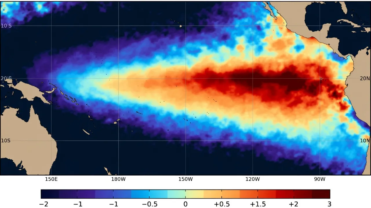
For decades, scientists have tracked the rhythmic, complex pulse of the Pacific Ocean, monitoring the natural climate process known as El Niño. This phenomenon, defined by the warming of central and eastern tropical Pacific waters, acts as a massive engine for global weather patterns. But on October 22, 2026, that engine hit a mark that researchers had never documented before. For the first time in recorded history, sea surface temperatures in the equatorial Pacific reached 30°C. This milestone, confirmed by the National Oceanic and Atmospheric Administration (NOAA), serves as a stark indicator of an exceptionally strong El Niño event currently reshaping the climate landscape.
To understand why a 30°C reading is so significant, one must look at the deviation from the norm. The warming is not merely a localized spike; it is part of a broader, more intense thermal anomaly. Current forecasts suggest that during the window of October to December 2026, these temperatures could escalate to above normal levels. This represents a profound shift in the energy balance of the Pacific, a change that the World Meteorological Organization (WMO) warns could potentially surpass the records set during the 2015-2016 event. When the Pacific warms to this degree, it disrupts the atmospheric circulation that dictates rainfall and temperature across the globe, turning typically wet regions into drought-stricken landscapes and bringing floods to areas that are usually arid.

🚨: The 2026 “Super El Niño” is projected to be the strongest in 150 years https://t.co/uifb45kQil
While the warming is centered in the Pacific, the consequences are felt thousands of miles away. India, in particular, is finding itself at the front lines of this atmospheric upheaval. The India Meteorological Department (IMD) has been closely monitoring the impact of this El Niño on the nation’s vital agricultural and weather cycles. The 2026 southwest monsoon, which serves as the lifeblood for much of the country's water supply and farming, concluded with a notable deficit. Rainfall levels were approximately 13 percent below normal, a shortfall that underscores the immediate, tangible danger posed by the shifting Pacific temperatures.
Rainfall levels were approximately 13 percent below normal, a shortfall that underscores the immediate, tangible danger posed by the shifting Pacific temperatures.
As the world moves through the final months of 2026, the focus remains on the peak of this warming trend. The WMO anticipates that the most extreme conditions will manifest between October and December. For a country like India, this means the challenges are far from over. Beyond the rainfall deficit already recorded, the IMD is bracing for higher-than-average temperatures in the coming months. The combination of a weakened monsoon and the lingering heat from the El Niño event creates a precarious environment, one where the predictability of seasonal weather is increasingly undermined by the record-breaking thermal energy stored in the equatorial Pacific.

🚨: A super El Niño is forming in the Pacific - the biggest since the recorded history Get ready for extreme winters since 1877! https://t.co/5YKzaIe0wt
We are currently witnessing a climate event that challenges our historical understanding of the Pacific Ocean. The 30°C threshold is more than just a number on a chart; it is a signal of a system under significant stress. As the anomaly persists through the end of the year, the global community is left to navigate the consequences of a climate that is behaving in ways we have never seen before. Whether this event marks a new baseline for future El Niño cycles or remains an outlier, the impact on global weather stability—and the specific, measurable toll on regions like India—remains the defining environmental story of the year.